The Beginning of Village-Level Destruction
The first five days following 25 August 2017 witnessed the rapid spread of violence across Rohingya settlements in northern Arakan. The military campaign affected communities separated by considerable distances, including coastal and riverine villages in Maungdaw, agricultural settlements in Buthidaung and Rohingya communities in Rathedaung. The timing and circumstances differed between locations, but the available eyewitness evidence reveals how quickly ordinary village life was transformed into a struggle for survival.
For Rohingya residents, the opening days were experienced through events in their immediate surroundings: gunfire near settlements, the arrival of armed personnel, houses catching fire, neighbours fleeing and families losing contact with relatives. Many witnesses could identify the places where violence occurred because they had lived in those communities for years. Their accounts are particularly important in reconstructing the chronology of settlements that independent journalists were unable to enter.
This chapter examines the sequence of attacks rather than repeating the military command structure or the complete narratives of individual massacres. It draws upon contemporary Rohingya reporting, interviews conducted with refugees and satellite observations. Where a precise date is uncertain, the distinction between eyewitness recollection, community reporting and independently dated imagery is maintained.
25 August. Chein Kar Li, Rathedaung Township
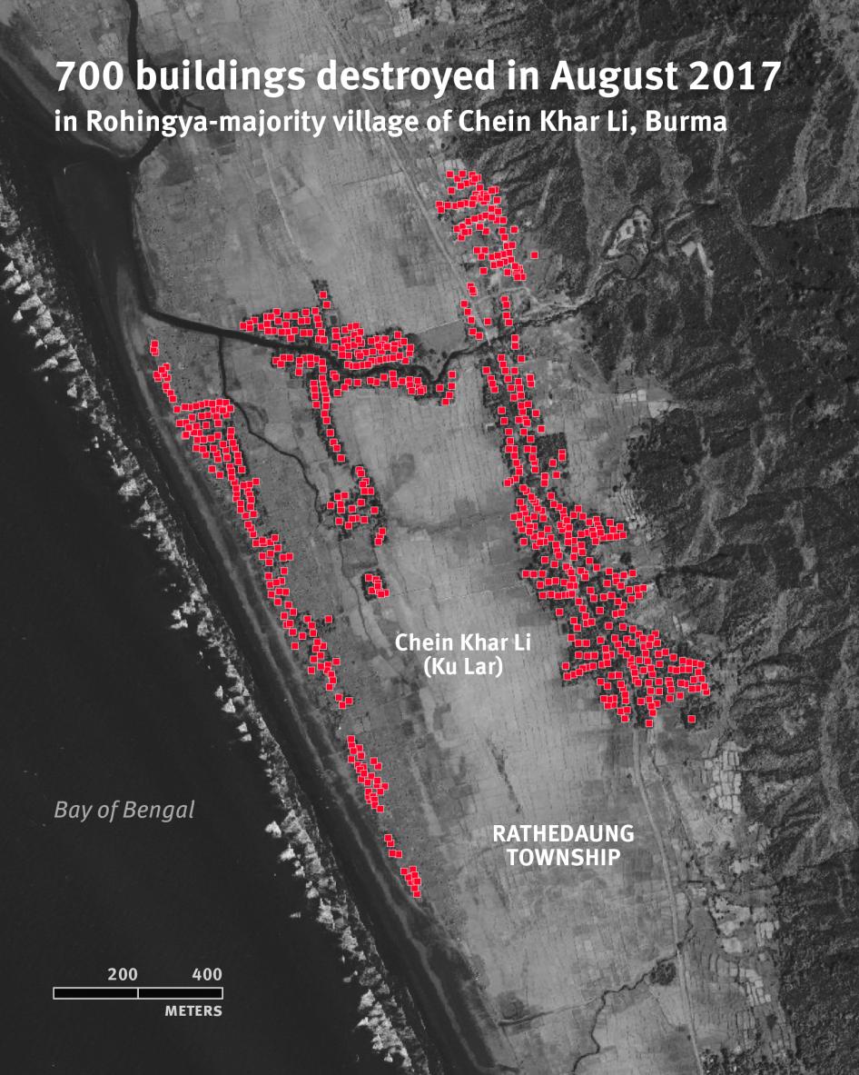
The attack was especially significant because it occurred in an area where Rohingya villages stood close to settlements inhabited by other communities. The geographical proximity made it possible for later satellite investigations to compare destruction across neighbouring locations. Human Rights Watch subsequently identified extensive fire damage affecting the Rohingya settlement, while adjacent areas remained substantially intact.
An emergency situation report circulated on 29 August through Rohingya and Myanmar civil society networks recorded allegations of numerous deaths and extensive destruction at Chein Kar Li on 25 August. Those figures reflected information available during the crisis and should not be treated as a final verified casualty count.
The evidence establishes Chein Kar Li as an important early site of violence. The detailed examination of the attack, its victims and the destruction of the village should be reserved for a dedicated village investigation rather than reproduced in full here.
25 August. Inn Din, Southern Maungdaw
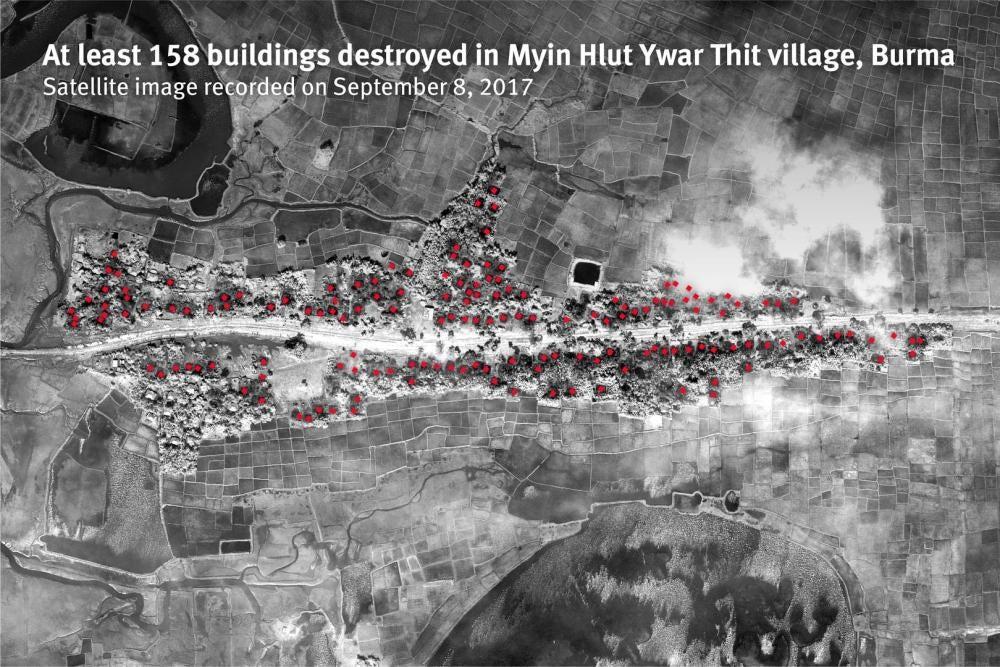
The witness concealed himself in a nearby forest and described military personnel remaining in the area for several days. During that period, he reported seeing houses looted and burned. His testimony is important because it establishes that the attack was not necessarily a single brief confrontation. The violence and destruction continued after the initial arrival of security forces.
Subsequent satellite analysis showed extensive damage to Rohingya residential areas while nearby non-Rohingya areas remained largely undamaged. The imagery provided independent evidence of the geographical concentration of destruction, although it could not establish every act committed during the attack.
The events in Inn Din should also be distinguished from the later killing of ten Rohingya men that became the subject of a Reuters investigation. That incident deserves separate treatment in Chapter 6. Here, the focus is the beginning of the village's destruction and the experiences of residents during the opening days.
25–26 August. Reports From Northern and Southern Maungdaw
Rohingya community reporting from 25 and 26 August identified violence in several other Maungdaw locations, including Loung Don, Nan Thar Taung, Myint Hlut, Thi Ho Kyun, Kyauk Pan Du and Aung Seik Pyin. Reports circulated during the crisis described deaths, injuries and the burning of residential areas.
These accounts are valuable because they preserve a wider geographical picture than investigations concentrated on a few major massacres. They indicate that Rohingya communities were reporting attacks from multiple parts of Maungdaw during the first forty-eight hours.
However, the early reports were compiled while communications were disrupted and access to affected villages was severely restricted. Their casualty figures and precise dates were not uniformly independently verified. The reports should therefore be preserved as contemporary Rohingya documentation rather than presented as a complete and settled accounting of every death.
The names of these settlements are also important. Several appear in different spellings across Rohingya testimony, Myanmar administrative records and international publications. Maintaining these variations can help researchers connect local accounts with official village-tract records and satellite locations.
26 August. Myo Thu Gyi, Maungdaw Township
Myo Thu Gyi became another important location in the opening phase of the campaign. A Rohingya resident interviewed by Amnesty International described an attack on 26 August, reporting that soldiers opened fire on houses and people during the late morning. According to his account, shooting resumed later that afternoon, after which houses were set alight.
The witness described destruction continuing over several days. His account therefore identifies 26 August as the beginning of the attack he experienced, not necessarily the date on which every structure was destroyed.
Amnesty International subsequently examined satellite fire-detection data and identified large-scale fires in Myo Thu Gyi on 28 August. This provides a useful example of how eyewitness testimony and satellite evidence can establish different parts of the same chronology. A survivor may identify when soldiers first entered a settlement, while satellite data can confirm that major fires were active on a later date.
Myo Thu Gyi is particularly relevant to understanding the spread of destruction around Maungdaw town. The attacks were not confined to remote rural settlements but also affected Rohingya neighbourhoods and communities close to an important administrative centre.
26–27 August. The Buthidaung Villages
In Buthidaung Township, the first days of the crisis affected villages surrounding local military and border-security installations. Rohingya accounts collected by Human Rights Watch described gunfire near Hpaung Taw Pyin, known locally as Pondu Para, during the early hours of 25 August. Residents subsequently fled their homes as security operations developed in the surrounding area.
The neighbouring community of Maung Nu, known locally as Monu Para, became an important place of refuge for people seeking safety. Families gathered in residential compounds because they feared that remaining in isolated houses would expose them to greater danger.
Contemporary Rohingya situation reports also identified violence in other Buthidaung locations during 26–27 August, including settlements associated with Maung Gyi Doung and Yin Ma Kyandang. These accounts recorded alleged deaths, injuries and house burnings. The reports demonstrate the breadth of local documentation, although their individual figures require separate verification.
The Buthidaung evidence is important because it shows that the crisis extended across more than one military-operational area. Rohingya communities in different townships experienced violence during overlapping periods, even when they had no direct connection with attacks on security installations.
27 August. The Maung Nu Massacre Begins
According to the witnesses, soldiers entered the compound and separated men and boys from other residents. Survivors described killings inside the compound and surrounding area. Human Rights Watch concluded that soldiers had summarily executed several dozen Rohingya, while acknowledging that it could not independently establish the total number killed.
The attack is particularly important to the chronology because it demonstrates that organised killings were taking place in Buthidaung within two days of the initial security-post attacks. The evidence also identifies the movement of civilians into supposed places of safety before they were attacked.
The detailed survivor testimony, identities of victims, alleged perpetrators and questions concerning the removal of bodies should be examined in the dedicated Maung Nu case study. Chapter 3 records the event's place in the opening chronology without repeating that later investigation.
27 August. Chut Pyin, Rathedaung Township
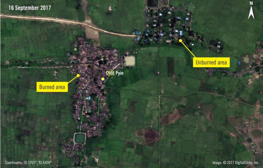
The accounts describe military personnel, Border Guard Police and participating armed civilians surrounding the village and attacking Rohingya residents. Families attempted to flee while houses burned and gunfire continued. The testimonies documented a particularly devastating attack on a civilian settlement.
The significance of Chut Pyin extends beyond the number of reported victims. It is one of the locations where survivor testimony, medical evidence and subsequent forensic analysis have been used together to investigate the circumstances of the attack.
The full reconstruction belongs to Chapter 4. In this chapter, Chut Pyin establishes the continuation of major attacks in Rathedaung on 27 August, following the destruction reported at Chein Kar Li two days earlier.
27 August. Koe Tan Kauk, Rathedaung Township
Koe Tan Kauk was another village affected during the opening days. Amnesty International recorded testimony from Sona Mia, an elderly Rohingya resident, who described soldiers surrounding the settlement and opening fire on 27 August.
His account illustrates the particular vulnerability of families attempting to escape with relatives who could not move independently. He described how his family struggled to carry his adult daughter, who had a disability, toward safety while the attack was underway.
The testimony is significant because it identifies a specific date, location and witness whose experience can be compared with other accounts from the area. It also demonstrates that the effects of an attack cannot be understood solely through casualty totals or the number of destroyed houses.
Some contemporary Rohingya reports place additional destruction at Koe Tan Kauk on 28 August. These accounts may describe the continuation of the same attack rather than a separate event. The distinction requires attention when reconstructing the chronology.
The Pattern Visible by the Evening of 27 August
By the evening of 27 August, major attacks had been reported in all three northern townships. Chein Kar Li and Inn Din had been attacked on 25 August; Myo Thu Gyi had experienced violence beginning on 26 August; and Maung Nu, Chut Pyin and Koe Tan Kauk had become important sites of documented atrocities by 27 August.
The evidence does not establish that every village was attacked through an identical procedure. Some residents described sudden gunfire, others reported encirclement followed by burning, and still others described violence continuing over several days.
Nevertheless, the geographical spread and overlapping dates demonstrate that Rohingya communities were facing a broad campaign rather than a single localised confrontation. Independent investigators later identified recurring patterns of violence across the affected settlements.
28 August. Continuing Destruction in Maungdaw
By 28 August 2017, the violence in Maungdaw Township had extended beyond the villages where attacks were first reported. Rohingya residents described settlements being attacked over successive days, with shooting, displacement and the burning of houses occurring at different stages. The destruction was not confined to the immediate surroundings of the security installations attacked on 25 August.
The experience of Myo Thu Gyi illustrates this progression. As examined in Part A, a Rohingya survivor identified 26 August as the day soldiers first attacked his community. He described renewed shooting later that afternoon and house burning that continued for approximately three days. Amnesty International subsequently identified major fires in the settlement on 28 August through satellite fire-detection data.
This distinction is important for reconstructing the chronology. The date of the first attack, the date of a major fire and the date on which a settlement became uninhabitable were not necessarily identical. For Rohingya families, an attack could unfold over several days rather than ending when soldiers first entered the village.
28 August. Fires Detected Across Multiple Maungdaw Locations
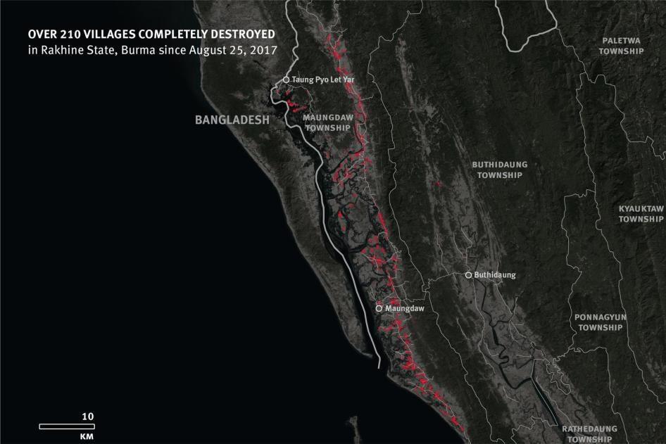
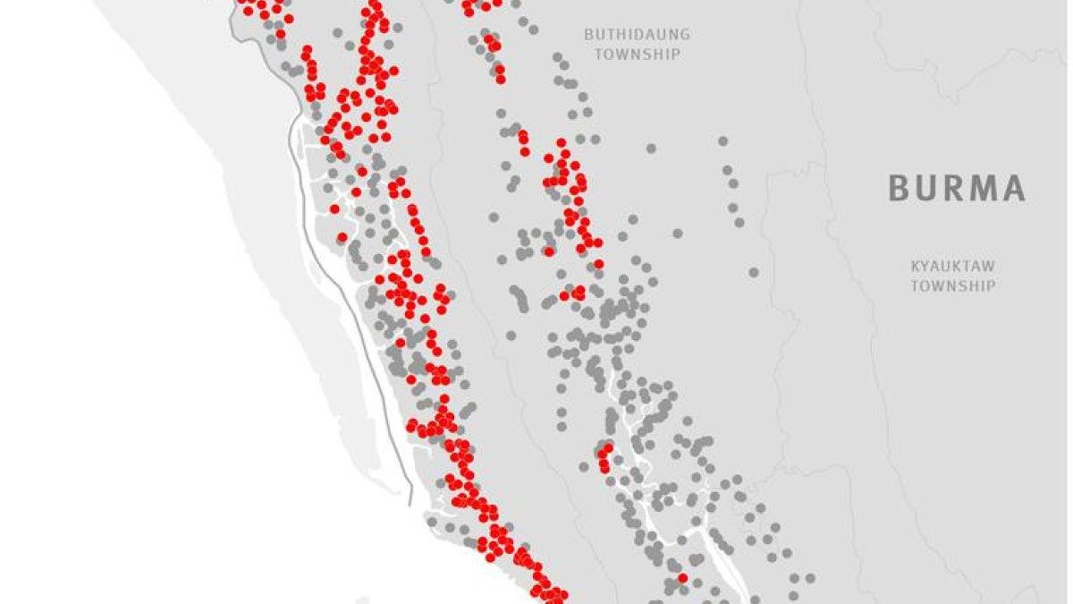
On 28 August, satellite sensors detected active fires at eight additional locations in northern Arakan, including Maungdaw town and several villages in Maungdaw Township. Human Rights Watch published these findings on 29 August, providing contemporary evidence that destruction was spreading rapidly.
The detected fires were geographically dispersed rather than concentrated around one security post. Human Rights Watch found that the fire locations recorded between 25 and 28 August extended across an approximately 100-kilometre stretch of northern Arakan. The findings challenged any suggestion that the destruction was confined to a single local confrontation.
The satellite observations had limitations. They identified heat signatures consistent with active fires but could not independently determine who started each fire. Heavy monsoon clouds and the resolution of the sensors also meant that some burning settlements were likely missed.
Rohingya eyewitness accounts supplied the human context for these observations. Their descriptions of soldiers entering villages, residents fleeing and houses subsequently burning provided evidence that could be compared with the geographical locations of detected fires.
Taung Pyo Let Yar. The Northern Maungdaw Frontier
Taung Pyo Let Yar, near the Bangladesh border in northern Maungdaw, was among the areas where Human Rights Watch compared satellite fire detections with refugee testimony. A Rohingya man who fled the area described security forces firing while pursuing suspected militants and reported that homes were subsequently burned.
His testimony provided an important link between the technical evidence of fires and the experiences of residents. The satellite data indicated burning in the area, while the witness described the circumstances in which civilians encountered security forces.
The available evidence does not establish that every structure in Taung Pyo Let Yar burned on 28 August specifically. The village's destruction must be understood as part of a developing sequence of violence, with later photographic evidence also documenting fires near the border.
For Rohingya residents, the proximity to Bangladesh did not guarantee safety. Families still faced the difficulty of leaving their settlements and reaching a place where they could escape the immediate danger.
Kyein Chaung. Warnings of Impending Destruction
Amnesty International documented an account from Kyein Chaung in Maungdaw Township in which a Rohingya resident described a warning communicated by the village administrator. According to the witness, villagers were told that the military might soon burn their houses and were encouraged to move toward the nearby riverbank.
The testimony is important because it concerns information allegedly communicated before destruction occurred. Rather than describing only an attack after the event, it raises questions about whether local authorities possessed advance knowledge of impending military activity.
The published account does not provide sufficient information to assign every stage of the Kyein Chaung incident to 28 or 29 August. It is included here as evidence relevant to the opening phase of the campaign, not as a separately verified attack on one of those two dates.
The account also demonstrates why Rohingya testimony is important for investigating operational intent. A satellite image can show that houses were destroyed, but it cannot reveal what an administrator told residents beforehand or whether they were given an opportunity to protect their families and belongings.
27–28 August. Gu Dar Pyin and the Surrounding Settlements
Gu Dar Pyin, in Buthidaung Township, became the site of serious violence during the night of 27–28 August and the following period. Amnesty International's later investigation documented testimony from Rohingya residents and people from neighbouring communities concerning the sequence of events.
The investigation recorded accounts of gunfire and explosions beginning during the night. Witnesses described a rapidly deteriorating security situation, followed by military activity and violence affecting the Rohingya settlement.
The chronology is important because some descriptions refer to 27 August as the date of the massacre, while others distinguish the events of that night from actions taking place on 28 August. A historical reconstruction should not force these accounts into one simplified date without explaining what each witness observed.
Gu Dar Pyin also became associated with allegations of mass graves and the concealment of victims' bodies. Those allegations require detailed examination of survivor testimony, photographic evidence, burial locations and subsequent investigations.
The complete Gu Dar Pyin case study is reserved for Chapter 7. Here, the purpose is to place the opening violence within the chronology of the wider campaign in Buthidaung.
Rathedaung. Violence Continuing Beyond the Initial Attacks
In Rathedaung Township, the attacks documented at Chein Kar Li, Chut Pyin and Koe Tan Kauk were followed by continuing insecurity and displacement. Some survivors described destruction occurring over more than one day, while others reported fleeing before they could determine the full extent of damage to their homes.
The experiences of these villages demonstrate the difficulty of assigning a single date to the destruction of an entire community. An initial attack could force residents to leave, while houses continued to burn or were destroyed after the surviving population had escaped.
Human Rights Watch's early satellite analysis detected fires in Koe Tan Kauk and Zay Di Pyin on 25 August. This establishes that burning was already occurring in Rathedaung on the first day, even though survivor accounts from particular settlements also describe later attacks.
The evidence therefore indicates overlapping phases of violence rather than a simple sequence in which one township was attacked only after another. By 28–29 August, Rohingya residents across the northern townships were facing the consequences of attacks that had begun at different times.
29 August. The First Public Satellite Assessment
By the evening of 29 August, Human Rights Watch had published an assessment identifying active fires in at least ten locations during the first four days of the crisis. The findings provided an early independent indication of the geographical extent of destruction.
This assessment was significant because Myanmar's authorities continued to present the situation primarily through official security statements. Independent journalists and investigators had extremely limited access to affected villages, making it difficult to assess the accounts emerging from Rohingya communities.
Satellite observations could not establish every death, injury or act of destruction. Nevertheless, they demonstrated that major fires were occurring across a much wider area than the locations of the initial security-post attacks.
The findings also provided a basis for further investigation. Researchers could compare the identified locations with Rohingya village names, interview survivors from those areas and examine higher-resolution imagery when it became available.
The Importance of Contemporary Rohingya Reports
Rohingya community networks played an important role in documenting the opening days. Reports circulated through relatives, displaced residents, community organisations and people who maintained contact with affected settlements.
These accounts often contained village names, descriptions of attacks and preliminary casualty estimates before international organisations could interview survivors. Their value lies partly in preserving information close to the time of the events, particularly when witnesses later became dispersed across different refugee settlements.
At the same time, early reports were produced under exceptionally difficult circumstances. Communications were interrupted, people were fleeing, and information sometimes passed through several individuals before reaching organisations outside Arakan.
Rohipedia should therefore preserve the original dates and village names recorded in these reports while distinguishing eyewitness observations from information relayed by others. Where later investigations corroborate an account, that relationship should be identified. Where the evidence remains incomplete, the uncertainty should remain visible.
What the Opening Five Days Reveal
The evidence from 25–29 August demonstrates that violence against Rohingya communities spread across multiple locations within a short period. In some villages, residents described soldiers opening fire before houses were burned. In others, the sequence included warnings, flight, subsequent destruction or attacks continuing over several days.
The satellite evidence provides an independent geographical record of the expanding fires. Eyewitness testimony explains how those events affected the inhabitants of particular settlements and identifies alleged perpetrators, local circumstances and the decisions families made as danger approached.
The evidence does not support treating every reported incident as identical. Some village attacks have precise eyewitness chronologies, while others remain documented through preliminary community reports or satellite observations that establish only a broader period of destruction.
Conclusion. The Transition to the Major Massacres
By 29 August 2017, the foundations of the catastrophe were already visible. Rohingya villages had been attacked across all three northern townships, major fires had been independently detected, and survivors were reporting violence that had destroyed families and forced entire communities from their homes.
The chronology established in this chapter provides the geographical and historical framework for the detailed investigations that follow. It identifies when particular communities first experienced violence while leaving the full examination of individual massacres to their dedicated chapters.
Chapter 4 begins with Chut Pyin in Rathedaung Township, examining the massacre through Rohingya survivor testimony, the identification of perpetrators and the evidence collected by independent investigators.