Chapter 9. October 2012: The Second Wave of Organized Violence
Section 1. 21–23 October: A Coordinated Second Wave Begins
The violence that erupted across Arakan in late October 2012 differed significantly from the first wave in June. June had developed from a sequence of incidents and confrontations before spreading through Maungdaw, Akyab/Sittwe and surrounding areas. The October violence appeared across a much broader geography in a compressed period of time. Muslim villages and neighbourhoods in several widely separated townships came under attack, including places that had experienced little or no comparable violence during June. Large groups of armed Rakhine men moved toward Muslim settlements by road, on foot and through Arakan's waterways, while survivors described attackers arriving from communities other than their own.
For Rohingya organisations, the pattern was evidence that the second wave was not a spontaneous recurrence of neighbourhood conflict. In statements issued while attacks were still underway, Rohingya groups described organized mobilization against Muslim communities and accused Rakhine nationalist networks, monks and elements of the authorities of facilitating the violence. These claims were initially made under emergency conditions and individual allegations require attribution. Their broader contention, however—that substantial preparation and coordination preceded the October attacks—was later supported by Human Rights Watch's extensive investigation.
Human Rights Watch concluded that after months of rising anti-Muslim mobilization and visible planning, large groups of armed Rakhine attackers descended on Muslim communities beginning around 22 October. The violence eventually affected nine of Arakan State's seventeen townships: Minbya, Myebon, Mrauk-U, Pauktaw, Kyaukphyu, Ramree, Kyauktaw, Rathedaung and Thandwe. Most of these townships had not experienced the major June violence. The geographical expansion is therefore essential to understanding October: violence was no longer concentrated principally in the Rohingya-majority north and the state capital but was reaching Muslim minorities across central and southern Arakan.
The timing also raised serious questions about organization. Human Rights Watch found that attacks occurred on the same day in townships separated by considerable distances. On 23 October, Muslim communities in Mrauk-U, Minbya, Kyaukphyu and Pauktaw were attacked within the same broad period. Some attacks began early in the morning and continued for hours. Such simultaneity did not by itself prove the existence of one centralized command directing every attacker, but it made an explanation based entirely on unrelated local disputes increasingly difficult to sustain.
Witness testimony reinforced this concern. Rohingya survivors from several locations told Human Rights Watch that many attackers were not people they recognized from neighbouring Rakhine communities. Residents familiar with the population surrounding their villages described crowds considerably larger than the local Rakhine population could readily explain. They therefore believed that participants had travelled from other villages or townships specifically to join the attacks.
The methods of movement also indicated substantial mobilization. In some areas attackers arrived in large groups on foot or by road. In coastal and riverine locations, witnesses described groups travelling in boats, taking advantage of Arakan's extensive waterways to approach Muslim settlements. Human Rights Watch described what amounted in some locations to organized flotillas of small boats carrying men toward targeted communities. Moving hundreds or thousands of people over significant distances required communication, transportation and advance knowledge of where groups were assembling.
The attackers were also frequently equipped with weapons and materials suited to destroying settlements. Witnesses described machetes, swords, spears, sticks, homemade firearms and Molotov cocktails or other incendiary materials. Human Rights Watch found that burning entire Muslim villages became a characteristic method during the October attacks. Mosques were often targeted before or alongside surrounding houses. The repeated use of similar methods across different locations strengthened concerns that the violence reflected shared planning and objectives rather than wholly independent local confrontations.
Contemporary Rohingya organisations were reporting this pattern almost immediately. In a 24 October joint statement, Rohingya organizations described renewed attacks in Minbya, Mrauk-U, Pauktaw and Kyaukphyu, alleging that organized Rakhine groups had already burned more than 1,000 Muslim houses and killed large numbers of Muslims. The statement accused police, army and other security forces of supporting or permitting the attacks. These casualty and responsibility claims should remain attributed to the organizations that issued them, but the statement is historically valuable because it shows that Rohingya networks were describing the attacks as organized while the second wave was still unfolding.
Kaladan Press Network likewise reported attacks spreading through Minbya, Mrauk-U, Kyaukphyu, Pauktaw, Rathedaung, Myebon and Kyauktaw. Its reporting reflected the Rohingya interpretation that nationalist political networks were mobilizing Rakhine crowds against Muslim communities. As with other contemporary community reporting, individual numerical claims require independent corroboration. Yet the geographic pattern reported by Rohingya sources closely resembles the pattern later established through witness interviews and satellite analysis.
The scale of the attacking groups is another important feature of the October record. Human Rights Watch documented accounts of mobs numbering in the hundreds and sometimes thousands. Such numbers mattered particularly in villages where Rohingya or other Muslim residents constituted a local minority. Even communities that attempted to organize rudimentary self-defence could be overwhelmed by much larger groups arriving from outside the immediate area.
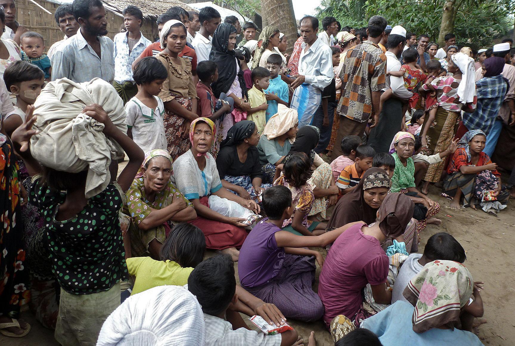
The second wave also affected Kaman Muslims, an officially recognized ethnic nationality of Myanmar. This is important because it demonstrates that the October attacks could not be explained solely as a dispute over the citizenship status of Rohingya. Muslim communities whose citizenship status differed fundamentally from that of the Rohingya were also attacked. Their experience will be examined separately in Chapter 11, but their presence among the October victims already indicates that anti-Muslim mobilization had become an important component of the violence.
Security forces were present in varying numbers across the affected townships. Their behaviour was not identical everywhere. Human Rights Watch documented cases in which army or navy personnel protected Rohingya and Kaman Muslims or assisted people fleeing attacks. In many other locations, however, security forces were absent, insufficient, failed to intervene, or were accused of collaborating with attackers. The question of security-force conduct has already been examined institutionally in Chapter 6 and will not be repeated here. For the October chronology, the important fact is that threatened Muslim communities frequently faced attacking groups far larger than the security presence available to protect them.
There were also indications that authorities had received warnings before some attacks. Human Rights Watch later recorded testimony from political representatives who said they had warned officials that violence was expected in places including Kyaukphyu. The existence and handling of such warnings will be important when Chapter 13 examines organization and state responsibility. At this stage of the chronology, it is sufficient to note that the October attacks did not necessarily arrive without warning.
The geographical and temporal pattern therefore distinguishes October from an explanation based purely on spontaneous local retaliation. Multiple Muslim communities separated by considerable distances were attacked within the same period; substantial groups of armed men travelled to targeted locations; similar incendiary tactics appeared across townships; and Rohingya witnesses repeatedly described attackers whom they did not recognize as local residents. Human Rights Watch later characterized the attacks as planned and coordinated.
This does not mean that every person participating in the October violence was directed by one organization or that every incident followed an identical plan. Local grievances, rumours, communal fear and individual actors undoubtedly contributed to events in particular places. Historical accuracy requires distinguishing evidence of broad organization from claims of a single centralized command for which separate proof would be necessary.
From the Rohingya perspective, however, the distinction between June and October was already unmistakable. Communities that had survived the first wave watched violence appear almost simultaneously across parts of Arakan that had previously remained comparatively untouched. The political campaigns for separation described in the previous chapter were now followed by the physical destruction of additional Muslim settlements.
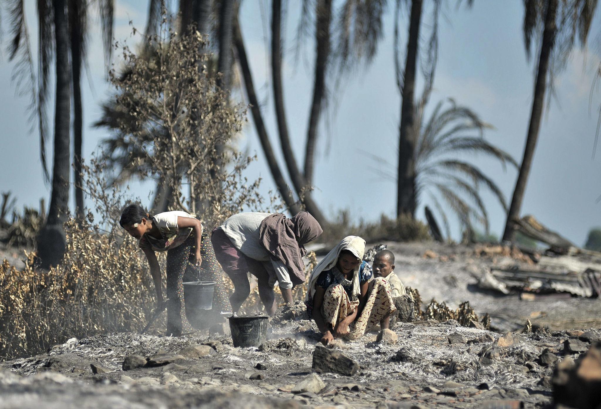
The massacre at Yan Thei and the simultaneous destruction of surrounding Muslim villages provide some of the clearest evidence for understanding the character of the October wave.
Section 2. Mrauk-U and Yan Thei: Mass Killing and Village Destruction
Among the attacks of October 2012, the events in Mrauk-U Township provide some of the most disturbing evidence of the vulnerability faced by Rohingya communities during the second wave. The township contained Rohingya and other Muslim villages surrounded by substantially larger Rakhine populations. When violence reached these communities on 23 October, residents confronted attacking groups that witnesses described as numbering in the thousands. The events at Yan Thei, in particular, became one of the deadliest documented episodes of the entire 2012 crisis.
Human Rights Watch later reconstructed the attack through survivor testimony and other evidence. According to its investigation, approximately 4,000 Rohingya lived in Yan Thei before the attack. The village was geographically vulnerable, surrounded by Rakhine communities and with limited possibilities for escape. In the days before 23 October, residents were already aware of rising tensions and feared that their village could be targeted.
Rohingya testimony indicates that the villagers attempted to prepare themselves for possible attack using whatever rudimentary means were available. Their ability to defend the village, however, was reportedly weakened before the main assault. Survivors told Human Rights Watch that local security personnel instructed Rohingya residents to surrender weapons they had assembled for self-defence. According to the witnesses, villagers complied because they believed the authorities would protect them.
This allegation is crucial to understanding the Rohingya account of Yan Thei. The villagers did not describe themselves simply as being overwhelmed by a larger crowd. They alleged that state personnel first reduced their ability to defend themselves and then failed to provide effective protection when the attack came. Human Rights Watch considered this testimony sufficiently important to include prominently in its subsequent investigation.
On the morning of 23 October, large numbers of Rakhine attackers approached Yan Thei. Survivors described a crowd vastly larger than the population of nearby Rakhine settlements, reinforcing their belief that people had travelled from other locations to participate. Witnesses described attackers carrying swords, machetes, spears, sticks and other weapons. The assault continued for hours.
Rohingya villagers attempted to protect families and prevent attackers from entering the settlement. But the numerical imbalance was overwhelming. Human Rights Watch reported that the security forces present failed to stop the attacking crowd effectively. Rohingya survivors described desperately attempting to defend the village while women, children and elderly residents sought safety.
The resulting killings were severe. Human Rights Watch documented that at least 70 Rohingya were killed in Yan Thei, including 28 children. The organization emphasized that the actual number could have been higher. The unusually large number of children among the documented dead demonstrates the civilian character of many of the victims. The dead were not confined to men participating in confrontation; families and children were caught in the attack.
For Rohingya, the Yan Thei death toll became one of the clearest pieces of evidence contradicting attempts to describe October simply as reciprocal communal rioting. Whatever violence may have occurred between individuals during the wider crisis, an attack in which dozens of residents of one village—including 28 children—were killed requires examination as a mass killing of civilians rather than being absorbed into the vague language of “clashes.”
Survivor testimony described scenes of families attempting to escape while attackers moved through or around the village. Some people reportedly fled toward fields and waterways. Others remained together because leaving the settlement exposed them to attackers surrounding the area. The village's geographical isolation consequently became part of the danger: there were few routes through which thousands of residents could safely escape.
Human Rights Watch also documented the destruction of homes during the attack. As elsewhere during the October wave, fire was used to destroy residential areas. For survivors, burning houses served two purposes simultaneously: it destroyed property and forced residents into open areas where they could be attacked or compelled to flee. The destruction therefore cannot be understood solely as property damage separate from the violence against the population.
The allegations concerning the authorities remained particularly serious. Rohingya survivors said security personnel who had taken away their weapons did not subsequently provide the protection that villagers believed had been promised. Human Rights Watch's later assessment treated Yan Thei as part of a wider pattern in which local authorities and security forces failed to prevent attacks despite evidence that violence was foreseeable.
The significance of this failure becomes clearer when considered against the scale of the approaching crowd. A village of civilians confronted by thousands of armed attackers could not reasonably be expected to maintain public order by itself. Preventing such an assault was precisely the function for which state security forces possessed weapons and legal authority. If villagers were instructed to disarm, the responsibility of the authorities to protect them became still greater.
Rohingya organisations reporting during the October violence described the killings in Mrauk-U as part of a broader campaign against Muslim villages. Their early casualty figures varied as information reached community networks, and some reports contained numbers that could not immediately be independently verified. Nevertheless, subsequent investigation confirmed that mass killing and extensive destruction had indeed occurred in the township.
Yan Thei was not the only affected Muslim settlement in Mrauk-U Township. Other villages and neighbourhoods experienced attacks, burning and displacement during the same period. Rohingya residents fled toward locations they believed might offer greater safety, while destruction removed families from communities in which they had lived for generations.
The pattern of attacks across Mrauk-U is important because it shows how the October wave operated beyond one famous massacre. The destruction of smaller or less internationally documented villages can disappear from historical narratives when attention concentrates on the location with the largest confirmed death toll. For Rohipedia, the long-term archive should therefore preserve the names of affected villages and reported victims wherever reliable Rohingya or independent documentation survives.
Human Rights Watch's satellite analysis later provided physical evidence of widespread destruction across areas affected during the October violence. Across Arakan State, its imagery documented thousands of destroyed structures in Muslim areas. Satellite evidence cannot identify the person responsible for an individual fire or determine the number killed inside a village, but it provides independent confirmation that destruction occurred on a scale consistent with survivor accounts of entire communities being burned.
The attack on Yan Thei also illustrates the relationship between killing and displacement. Residents who survived did not simply resume ordinary village life once the attackers withdrew. Deaths, burned homes, fear of renewed violence and the inability of authorities to guarantee protection drove survivors away. A village could therefore suffer three successive forms of destruction: people were killed, physical structures were burned, and the surviving population was displaced.
From the Rohingya perspective, Yan Thei became particularly significant because the evidence combined several elements repeatedly alleged during the second wave: advance fear of attack, a large crowd arriving against an isolated Muslim community, alleged disarmament of Rohingya by authorities, inadequate state protection, mass killing including children, burning of homes and displacement of survivors.
These elements do not by themselves answer every question concerning who organized the October violence. The evidence concerning political planning, nationalist networks, advance meetings and state responsibility will be assembled systematically in Chapter 13. But Yan Thei demonstrates why the October violence cannot adequately be understood through casualty statistics alone. The sequence experienced by survivors—anticipation, disarmament, attack, killing, destruction and displacement—must itself be preserved.
The massacre also reveals why a purely symmetrical description of the October violence can obscure important differences between communities. Rakhine civilians were killed and Rakhine property was destroyed during the wider 2012 crisis, and those losses remain part of the historical record. At Yan Thei, however, the documented event was an attack by a much larger Rakhine crowd upon an isolated Rohingya village that resulted in the deaths of at least 70 Rohingya, including 28 children. Historical accuracy requires describing that particular event according to its evidence rather than forcing every locality into a generalized formula of equal communal confrontation.
The destruction in Mrauk-U was occurring while Muslim communities elsewhere were facing attacks of their own. Minbya and Myebon experienced severe violence and displacement, while Pauktaw, with its coastal and island geography, became another major centre of destruction. Rohingya and other Muslim communities in these townships confronted attacking groups arriving by land and water, and further settlements were emptied.
The October wave was therefore continuing to move across central Arakan even as survivors of Yan Thei were attempting to account for their dead.
Section 3. Minbya, Myebon, Pauktaw and the Spread Across Central Arakan
While Rohingya were being killed and displaced in Mrauk-U Township, attacks were unfolding across other parts of central Arakan. Minbya, Myebon and Pauktaw were geographically distinct, yet Muslim communities in all three experienced violence, burning and forced displacement within the same late-October period. Their experiences are important because they demonstrate that the second wave cannot be reconstructed through one massacre or one town alone. By 23–25 October, destruction was spreading through a broad belt of central Arakan.
In Minbya Township, tension had been rising before the main attacks. Muslim communities lived among much larger Rakhine populations and were acutely aware of the anti-Muslim mobilization that had developed since June. When violence began, Rohingya and other Muslim residents faced large groups approaching settlements while communications with neighbouring Muslim communities were limited. Contemporary Rohingya organisations identified Minbya among the first areas affected during the renewed October violence.
Human Rights Watch subsequently documented attacks on Muslim villages in Minbya as part of the coordinated October wave. Witnesses described large groups of Rakhine men gathering and moving toward Muslim settlements. As in other townships, some residents reported that participants came from outside the immediate locality. Houses were burned, residents fled, and communities that had survived the June period without comparable destruction were suddenly uprooted.
Rohingya organisations reporting on 24 October described extensive burning in Minbya and neighbouring townships. Their reports alleged that organized groups were moving against Muslim villages and that security forces were failing to provide adequate protection. Early numerical estimates changed as additional information became available, and they should therefore remain attributed to the organisations that produced them. What subsequent independent investigation confirmed was the central fact behind those reports: Muslim settlements across Minbya were indeed attacked and substantial displacement occurred.
The geography of Myebon Township created another form of vulnerability. Muslim communities there were a minority surrounded by larger Rakhine populations and had limited routes through which large numbers of civilians could escape. When attacks developed, families faced the possibility of being trapped between hostile groups and waterways. Houses were burned and Muslim residents were driven from their communities.
The experience of Myebon became particularly consequential because displacement there rapidly developed into severe confinement. Survivors who fled their homes were gathered into restricted locations rather than being restored to their former communities. The detailed long-term conditions of those displacement sites belong to Chapter 12, but their origin lies directly in the October destruction: violence removed Muslims from their homes, and the arrangements created afterward prevented many from simply returning.
Human Rights Watch documented destruction in Myebon town through satellite imagery. Its analysis identified extensive areas of destroyed Muslim property following the October violence. As with the June satellite record, imagery cannot determine who started an individual fire, but it independently establishes that large concentrations of structures disappeared during the period in which witnesses reported attacks.
The transformation of Myebon's Muslim community illustrates an important feature of the October wave. Destruction did not end when attackers withdrew. Where an entire Muslim residential area was burned and its inhabitants subsequently concentrated elsewhere, violence altered the demographic geography of the township. The outcome resembled what had already begun in Akyab/Sittwe after June: a previously established Muslim population was physically separated from the wider town.
The violence in Pauktaw Township demonstrates still more clearly how organized movement could exploit Arakan's geography. Pauktaw consists of coastal and island communities connected by waterways. Large attacking groups could therefore travel by boat rather than relying solely on roads. Human Rights Watch documented testimony describing Rakhine attackers arriving in Muslim areas in organized groups using boats.
Survivors described seeing flotillas moving toward Muslim settlements. In some accounts, attackers arrived from locations beyond the immediate neighbouring village. The use of boats is historically significant because it required transportation and collective movement across waterways. While the existence of boat transport alone does not identify who organized an attack, it provides further evidence that substantial groups were mobilized beyond spontaneous confrontations between adjacent households.
Muslim villages in Pauktaw were burned during the attacks, forcing residents toward shorelines, boats and other settlements. For families living on islands or peninsulas, escape routes were especially limited. Water that ordinarily connected communities could become a barrier when boats were unavailable or when armed groups controlled movement.
Human Rights Watch's satellite analysis later documented extensive destruction in Pauktaw, providing independent physical confirmation of the scale described by survivors. In one of its assessments of the October violence, satellite imagery showed widespread destruction of buildings in affected Muslim areas. The imagery strengthened testimony that entire residential zones, rather than isolated houses, had been burned.
The attacks in Pauktaw also generated large-scale flight by water. Muslim residents boarded whatever boats they could obtain and moved toward locations they believed might provide safety. Some eventually joined the rapidly growing displaced population around Akyab/Sittwe. Others remained stranded in temporary locations with limited food, shelter or medical assistance.
For Rohingya and other Muslims, movement by sea or river was not necessarily safe. Boats could be overcrowded, families could become separated, and displaced people could spend days searching for somewhere willing or able to receive them. The coastal geography that had supported trade and communication before the violence now shaped the routes of forced displacement.
The experiences of Minbya, Myebon and Pauktaw also demonstrate why the October violence cannot be described solely as an extension of the citizenship dispute surrounding the Rohingya. Muslim populations across central Arakan included people with different legal statuses and community identities. Kaman Muslims, whose citizenship and recognized ethnic status differed from that of Rohingya, were also caught in the violence. Their experience is examined separately in Chapter 11 because it provides important evidence of the broader anti-Muslim dimension of the second wave.
Contemporary Rohingya organisations interpreted the simultaneous attacks across these townships as evidence of a campaign intended to remove Muslim communities from substantial parts of Arakan. Their statements repeatedly used language of organized destruction and accused nationalist networks of coordinating attacks. Some of their numerical claims remain difficult to verify independently, but the geographical pattern that prompted those conclusions was real: within a short period, Muslim settlements across several separate townships were being attacked, burned and emptied.
Human Rights Watch's later investigation reached a similar conclusion concerning the organized character of the second wave. Its evidence included the timing of attacks, movement of outside attackers, use of transportation, advance warnings and repeated targeting of Muslim communities across multiple townships. This does not establish that every local attack was directed by one central commander. It does demonstrate that October cannot plausibly be reduced to a series of unrelated quarrels erupting independently in neighbouring villages.
The role of local authorities and security forces varied considerably. Some Muslim survivors reported complete absence of effective protection; others described security personnel standing by or intervening only after substantial destruction had occurred. Elsewhere, state forces assisted threatened Muslims or helped evacuate survivors. These differences are important, but repeating the institutional analysis of Chapter 6 would obscure the central point of the October chronology: entire Muslim communities were being removed from locations across central Arakan within days of one another.
The pattern also shows how killing, destruction and displacement functioned together. A community did not need to suffer a massacre on the scale of Yan Thei in order to disappear from a township. Burning hundreds of houses and making return unsafe could achieve a similarly transformative demographic result. Residents might survive physically while losing their village, property, livelihood and ability to return.
For Rohingya, this was one of the most frightening features of the second wave. June had already demonstrated the consequences of destruction and segregation in Akyab. By October, similar processes were appearing across places that had escaped the first major wave. Each destroyed settlement expanded the geographical area from which Muslims were being removed.
By 24–25 October, reports of violence were coming from an increasingly wide portion of Arakan. Minbya, Myebon, Mrauk-U and Pauktaw had all experienced attacks, while violence was also affecting Kyauktaw, Rathedaung, Ramree and other locations. The number of displaced Muslims was rising rapidly, and humanitarian agencies faced the task of reaching populations scattered across roads, waterways and improvised places of refuge.
Yet one location would become the most visually documented symbol of the October destruction. In Kyaukphyu, a major Muslim quarter was almost completely burned, and thousands of Muslims fled toward the sea. Satellite imagery and photographs would later provide unusually powerful evidence of what had happened there.
Kyaukphyu therefore forms the final geographical component of the October chronology—but because of the scale of its destruction and the quality of surviving evidence, its full reconstruction is reserved for the next chapter.
Section 4. Kyaukphyu and the Wider October Record
By 24 October, the second wave had expanded beyond the townships examined in the preceding sections. Violence was being reported across a wide geographical arc of Arakan, and the accumulating evidence showed that Muslim communities separated by considerable distances were experiencing destruction within the same period. Kyaukphyu, Ramree, Kyauktaw, Rathedaung and other locations became part of a crisis that was no longer geographically confined to one region of the state.
Among these locations, Kyaukphyu became one of the clearest symbols of the October destruction. The coastal town contained a substantial Muslim population whose homes and businesses formed an established quarter close to the waterfront. On 23 October, violence engulfed the Muslim area. Large sections were burned, residents fled toward the shore, and thousands of Muslims were ultimately forced onto boats or toward places of refuge outside the town.
The destruction in Kyaukphyu is unusually well documented. Photographs taken during and after the attack show extensive burned areas, while satellite imagery later examined by Human Rights Watch demonstrated the near-total destruction of a major Muslim neighbourhood. Because this evidence permits a detailed reconstruction of individual neighbourhoods, the fires, displacement and flight by sea, Kyaukphyu is examined separately in Chapter 10. For the present chapter, its importance lies in its place within the wider October pattern: another substantial Muslim community was devastated on the same day that attacks were occurring elsewhere in Arakan.
Evidence that violence in Kyaukphyu was anticipated is also significant. Human Rights Watch subsequently documented testimony indicating that officials had received warnings that attacks were likely. Muslim political representatives and community figures reportedly attempted to alert authorities to the danger. Whether the response to those warnings was adequate forms part of the larger question of organization and state responsibility reserved for Chapter 13. What matters to the October chronology is that the destruction occurred despite indications that serious violence was foreseeable.
Violence also reached Ramree Township, an island area south of Kyaukphyu. Muslim communities there faced attacks, destruction and displacement during the October wave. Ramree's geography, like that of Pauktaw and Kyaukphyu, made waterways important both to the movement of attackers and to the escape of threatened civilians. Muslim residents in coastal areas could find themselves with few safe routes except by boat.
Further north, Kyauktaw Township also experienced attacks on Muslim communities. Rohingya organisations reported violence and burning there as the October crisis expanded. Human Rights Watch subsequently included Kyauktaw among the nine townships affected by the second wave. As elsewhere, residents faced a combination of physical attacks, destruction of property and displacement.
Rathedaung Township, situated between the Rohingya-majority north and central Arakan, was likewise affected. Rathedaung had already experienced communal tension and displacement during the earlier crisis, but the October wave brought renewed danger to Muslim villages. Its inclusion among the affected townships demonstrates the geographical continuity developing between northern and central Arakan as violence spread across the state.
The second wave eventually affected nine of Arakan State's seventeen townships: Minbya, Myebon, Mrauk-U, Pauktaw, Kyaukphyu, Ramree, Kyauktaw, Rathedaung and Thandwe. This geographical breadth is one of the most important facts of the October record. Many of these areas had not experienced major violence in June. The October attacks therefore represented not simply renewed fighting in previously affected places but a substantial territorial expansion of anti-Muslim violence.
By the end of the October wave, the human consequences were enormous. Government figures reported 89 people killed, 136 injured and more than 32,000 displaced during the renewed violence, while thousands of homes were reported destroyed. As with the June figures, official statistics did not resolve the full casualty record. Rohingya organisations reported higher Muslim losses and expressed particular concern about people whose whereabouts remained unknown.
Human Rights Watch subsequently estimated that more than 35,000 people were displaced by the October violence, overwhelmingly Muslims, adding to the populations already displaced since June. By the end of 2012, the combined displacement produced by the two waves had reached approximately 125,000 people, the great majority Rohingya and other Muslims. These figures illustrate the cumulative demographic impact of the violence: entire communities had been removed from towns and villages across Arakan within several months.
Physical destruction was similarly extensive. Human Rights Watch's satellite analysis identified thousands of destroyed structures across affected areas following the October attacks. Burn zones appeared in multiple townships, often concentrated in Muslim residential areas. The imagery provided an independent evidentiary record particularly valuable in locations where journalists and human-rights investigators could not observe the attacks directly.
The distribution of destruction matters as much as the statewide total. When hundreds of structures belonging to one community disappear from a single location, the result can be the effective elimination of that community from the town or village. In several October locations, this is precisely what occurred. Muslim residents survived the attack but no longer possessed an intact neighbourhood to which they could immediately return.
Rohingya organisations interpreted this pattern as evidence that the objective extended beyond retaliation or temporary communal fighting. In their statements, they described a campaign intended to remove Rohingya and other Muslims from substantial areas of Arakan. Their language reflected a community watching Muslim settlements disappear one after another while survivors were concentrated into displacement sites.
Later independent investigations gave significant weight to this interpretation of the pattern. Human Rights Watch concluded in its 2013 investigation that the October attacks were coordinated and described the broader campaign against Rohingya as involving crimes against humanity and ethnic cleansing. Its conclusion rested not on one incident alone but on evidence accumulated across locations: advance organization, movement of attackers, simultaneous attacks, widespread burning, security-force conduct and the subsequent treatment of displaced Muslims.
The October violence also demonstrates why the identity of the victims cannot be reduced solely to the Rohingya citizenship question. Kaman Muslims and other Muslim communities were attacked alongside Rohingya. Kaman are among Myanmar's officially recognized ethnic nationalities, yet their recognized legal status did not protect them from anti-Muslim violence. Their experience, examined in Chapter 11, provides important evidence that the second wave had developed a broader religious dimension even while Rohingya remained its principal and most vulnerable victims.
At the same time, the October record should not erase violence suffered by Rakhine civilians. Rakhine people were killed and injured, and Rakhine property was destroyed during the wider crisis. Individual crimes against Rakhine civilians require the same factual documentation as crimes against Muslims. Recognizing those victims does not require treating every locality as though violence occurred in identical proportions or circumstances. Each event must be reconstructed according to its own evidence.
What distinguishes the second wave historically is the overall pattern produced when those local records are placed beside one another. Within little more than a week, Muslim communities across nine townships experienced attacks. Large armed groups travelled toward targeted settlements. Similar burning tactics appeared across geographically separate locations. Some attacks occurred simultaneously. Thousands of structures disappeared, tens of thousands of people were displaced, and Muslim populations were removed from towns and villages that had escaped the June violence.
For the Rohingya historical record, October therefore represents a major escalation. The political mobilization and demands for separation that had intensified during the months after June were followed by a geographically broader wave of physical destruction. Areas in which Muslims had continued living after the first crisis were attacked, and the territory in which Rohingya and other Muslims could safely maintain ordinary community life contracted still further.
The evidence presented in this chapter establishes the organized characteristics of the October wave without attempting to resolve every question about who ultimately directed it. Rohingya organisations described the attacks as coordinated while they were occurring; survivor testimony documented outside attackers and organized movement; satellite imagery confirmed destruction across widely separated locations; and later Human Rights Watch investigation concluded that the attacks involved significant coordination. The evidence concerning political leadership, nationalist organizations, local authorities and possible state participation will be brought together in Chapter 13.
One location, however, deserves examination before moving to that wider analysis. Kyaukphyu provides perhaps the clearest visual case study of what the October violence could accomplish within a single town. A major Muslim neighbourhood was almost completely destroyed, thousands of residents were driven toward the sea, and satellite imagery preserved the physical evidence of their removal.
Its history allows the process of destruction and displacement to be reconstructed with unusual precision.
Continue reading → Part 13, Chapter 10. The Destruction of Kyaukphyu's Muslim Quarter and Flight by Sea