Chapter 10. The Destruction of Kyaukphyu's Muslim Quarter and Flight by Sea
Section 1. Kyaukphyu Before 23 October and the Approach of Violence
The destruction of Kyaukphyu deserves separate examination because unusually strong forms of evidence survive from the town. Survivor testimony, contemporary photographs, press reporting and high-resolution satellite imagery together make it possible to reconstruct not only that a Muslim neighbourhood disappeared, but approximately where the destruction occurred, how concentrated it was and how residents were driven toward the sea. Kyaukphyu consequently provides one of the clearest physical records of the demographic transformation produced by the October 2012 violence.
Kyaukphyu is a coastal town in western Arakan whose life has historically been closely connected to the sea. Before October 2012, Muslims formed an established part of the town's population and commercial life. The Muslim quarter lay along the eastern coastal edge, where houses, businesses and structures connected to the waterfront stood beside houseboats and floating barges. The community was therefore physically and economically connected to the harbour.
An important distinction must be preserved in the historical record. The Muslim population of the area destroyed in October was predominantly Kaman, rather than predominantly Rohingya. Human Rights Watch initially identified the destroyed area as a predominantly Rohingya quarter but subsequently issued a correction stating that it was predominantly inhabited by ethnic Kaman Muslims. Kaman are an officially recognized ethnic nationality of Myanmar and, unlike Rohingya, were not excluded from citizenship on the same legal basis. Their presence in Kyaukphyu is therefore highly significant: legal recognition as citizens did not protect a Muslim community from the October violence.
This does not make Kyaukphyu irrelevant to Rohingya history. On the contrary, Rohingya organisations followed and documented the attack because they understood it as part of the same widening anti-Muslim mobilization that was destroying Rohingya communities elsewhere in Arakan. The experiences of Rohingya and Kaman were not identical, and Rohipedia should not erase the Kaman identity of Kyaukphyu's victims. But the destruction demonstrates how the political environment directed principally against Rohingya had developed into a broader danger for Muslims.
Unlike several communities affected in June, Kyaukphyu had not previously experienced destruction on this scale. By October, however, the political atmosphere across Arakan had deteriorated considerably. News of attacks in other townships was spreading, and Muslim residents understood that the violence moving across central Arakan could reach them.
For Muslim residents, the preceding months had already undermined confidence that the state would necessarily provide effective protection. They had observed what had happened to Muslim communities elsewhere in Arakan and knew that physical separation and displacement could continue long after immediate violence ended. The appearance of threatening crowds therefore carried implications beyond the danger of a temporary street confrontation: residents could see that the destruction of a neighbourhood might mean permanent removal from the town.
By 23 October, tension had become acute. Human Rights Watch later interviewed a 49-year-old Kaman Muslim survivor who described large numbers of Rakhine people approaching the Muslim population near the seashore. His estimate placed the crowd at close to 2,000 people, while approximately 300 Muslim men prepared to defend their community. These figures are witness estimates rather than a formal count, but they convey the scale of the confrontation perceived by residents.
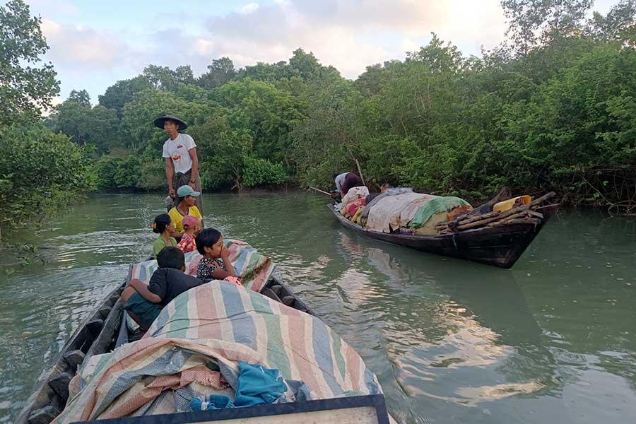
The Muslim community was already preparing boats. This detail is critical to the history of Kyaukphyu. Boats were not merely an incidental means of transportation used after the neighbourhood burned. They became part of the community's survival strategy as residents recognized that the sea might provide their only viable escape route. The geography of the town meant that flight inland could expose Muslim residents to larger hostile populations, while the waterfront offered the possibility—however dangerous—of leaving Kyaukphyu altogether.
The same survivor testimony also records violence committed by Muslim residents. As Rakhine men approached the boats, Muslim men armed themselves and prepared to fight. The witness described two Rakhine men being killed by members of the Muslim group, including one who was beheaded. This evidence must remain in the record. A Rohingya-supportive historical account gains credibility by preserving crimes committed by Muslims rather than suppressing them. What requires examination is the entire sequence and the scale of what subsequently happened to the Muslim quarter.
The army eventually intervened at the waterfront by firing into the air, causing Muslim defenders to retreat toward their boats. This is another example of the uneven security-force conduct documented throughout 2012. Yet Human Rights Watch also collected testimony alleging that local police killed Kaman Muslims during the Kyaukphyu violence, while army personnel failed to stop thousands of hostile Rakhine from entering the Muslim area. The detailed conduct of individual forces was examined institutionally in Chapter 6; here its importance lies in whether the Muslim quarter received effective protection when destruction began.
One Kaman survivor told Human Rights Watch that police and army personnel who had been routinely visible during the preceding month were not effectively present when tension reached its highest point on 23 October. His testimony reflects the central grievance later expressed by survivors: authorities knew communal tension existed, possessed armed forces capable of intervention, yet failed to prevent the destruction that followed.
Kyaukphyu therefore entered 23 October with several warning signs already present: violence was spreading through other townships, Muslim residents feared attack, community representatives had raised concerns, large groups were mobilizing, and the Muslim population was preparing boats in anticipation that escape might become necessary.
The physical evidence that survives from the following twenty-four hours makes the result unmistakable. Human Rights Watch compared satellite imagery taken before and immediately after the attack. On the eastern coastal edge of Kyaukphyu, it identified a concentrated destruction zone measuring approximately 35 acres. Within that zone, 811 structures were destroyed: 633 buildings and 178 houseboats and floating barges. The destruction was so concentrated that satellite imagery showed no comparable fire damage immediately to the east or west of the devastated zone.
Those numbers belong to the next stage of the reconstruction. They demonstrate that what happened in Kyaukphyu was not simply a street confrontation that accidentally ignited scattered houses. An established Muslim waterfront neighbourhood and the vessels alongside it were almost entirely consumed.
On 23–24 October 2012, the Muslim quarter burned, and its surviving population moved toward the sea.
Section 2. 23–24 October: The Muslim Quarter Burns
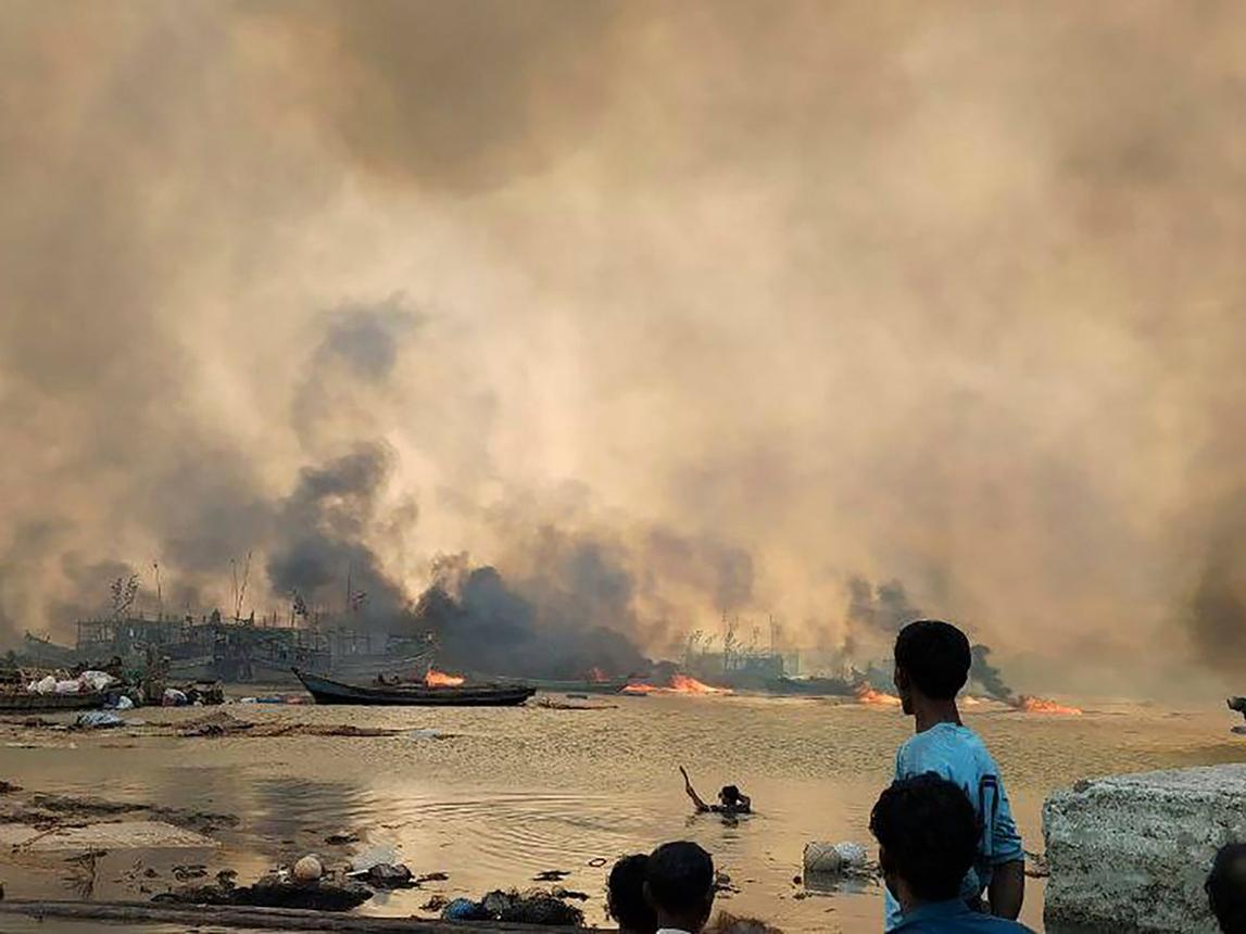
Survivor testimony collected by Human Rights Watch describes large numbers of Rakhine attackers moving into the Muslim area as residents attempted to defend their homes or retreat toward the sea. Houses were set on fire, and flames spread through the densely built waterfront quarter. The destruction affected not only residential buildings on land but also the houseboats and floating barges that formed part of the community's physical and economic life.
For families living close to the shore, the spread of fire created an immediate choice between remaining among burning houses and attempting to reach boats. Residents carried children, elderly relatives and whatever possessions they could retrieve toward the waterfront. Many had little time to collect property. Houses, businesses, documents, household goods and accumulated family wealth were abandoned as residents sought escape.
Photographs taken during the destruction provide unusually direct visual evidence. Images from Kyaukphyu show large columns of smoke rising from the Muslim quarter, while groups of people gathered near the shoreline and boats crowded the water. Unlike many incidents from 2012 for which only survivor testimony survives, the burning of Kyaukphyu was photographed while it was occurring. These images became some of the most recognizable evidence of the October violence.
Satellite imagery subsequently provided an even more systematic record. Human Rights Watch obtained high-resolution imagery taken less than a day after the reported arson and compared it with earlier images of the same area. The analysis identified a concentrated destruction zone of approximately 35 acres along the eastern coastal edge of Kyaukphyu.
Within this area, Human Rights Watch counted 811 destroyed structures. These consisted of 633 buildings and 178 houseboats or floating barges. The inclusion of vessels is particularly important because Kyaukphyu's Muslim community was economically and physically connected to the waterfront. Destruction therefore extended beyond houses on land to structures through which residents lived, worked and moved along the coast.
The concentration of the burn zone is also significant. Human Rights Watch reported that the satellite imagery showed no comparable fire damage immediately east or west of the destroyed area. This does not by itself identify who ignited every fire, but it demonstrates that the destruction was geographically concentrated within the Muslim quarter rather than representing an indiscriminate fire consuming the town in all directions.
For survivors, the pattern appeared deliberate. The neighbourhood in which their community had lived was being consumed while adjoining portions of Kyaukphyu remained standing. From the Kaman and wider Muslim perspective, the destruction therefore represented not simply property lost during communal fighting but the physical removal of their community from a particular part of the town.
The surviving evidence concerning security forces adds to this interpretation of vulnerability. Human Rights Watch collected testimony alleging that local police killed Kaman Muslims during the violence. One survivor described seeing police shoot Muslims, while other witnesses complained that security forces failed to prevent large Rakhine crowds from entering and burning the Muslim area. As established in earlier chapters, the conduct of security forces was not uniform, and army personnel intervened in some circumstances. Nevertheless, the presence of armed state forces did not prevent the Muslim quarter from being devastated.
The scale of destruction is particularly striking because the authorities possessed the means to recognize what was occurring. Hundreds of structures could not burn simultaneously without producing enormous smoke and visible fire. Kyaukphyu was not an inaccessible rural settlement hidden from state institutions. It was a significant coastal town, and the destruction unfolded over a large, concentrated area.
Contemporary Muslim and Rohingya organisations interpreted what was happening as part of the broader campaign against Muslims across Arakan. Rohingya networks reported the destruction of Kyaukphyu while attacks were simultaneously affecting other townships. Although the population of the destroyed quarter was predominantly Kaman, Rohingya organisations understood its destruction as evidence that the October campaign had developed beyond attacks directed solely at Rohingya citizenship claims.
This distinction is essential. The Kaman were recognized citizens. The legal argument repeatedly used against Rohingya—that they were allegedly foreigners without legitimate citizenship—could not straightforwardly explain the destruction of a predominantly Kaman neighbourhood. Kyaukphyu therefore provides powerful evidence that anti-Muslim mobilization had become an independent element of the October violence.
At the same time, the Kaman identity of the victims should not be absorbed into a generalized Rohingya narrative. Rohingya and Kaman communities had different histories and legal positions. Preserving those distinctions makes the evidence stronger. A recognized Muslim ethnic nationality and a stateless Rohingya population could experience related persecution without being identical communities.
The destruction also had an economic dimension. Houses and floating structures along the waterfront represented more than shelter. Businesses, trading connections, fishing-related activity and other livelihoods were concentrated there. Burning the quarter therefore destroyed both residential and economic infrastructure. Families who escaped did not merely lose roofs over their heads; many lost the material foundations through which they had supported themselves.
Religious and community institutions were also affected within the broader destruction. When an entire neighbourhood burns, community life disappears with individual houses. Places where people prayed, gathered, traded and maintained social relationships could no longer function. Even where a particular building survived, the displacement of the population surrounding it could render the institution unusable.
By the evening, the shoreline had become the principal route of escape. Survivors gathered around vessels while smoke rose behind them. Some boats were already overloaded as families attempted to leave Kyaukphyu. Others waited offshore or searched for places where displaced Muslims might safely land.
The scene was strikingly different from ordinary evacuation after a temporary emergency. Residents were not leaving with an expectation that firefighters would extinguish the blaze and they would return the following morning. Behind them, much of the physical neighbourhood that would have made return possible was disappearing.
The destruction continued into the night and the following day. By 24 October, the Muslim quarter visible in earlier satellite imagery had been transformed into an extensive burn zone. Hundreds of structures had disappeared. The physical evidence therefore preserved what survivors described: a concentrated Muslim neighbourhood had been almost entirely removed from Kyaukphyu's urban landscape.
For the historical record, the satellite count of 811 destroyed structures is particularly valuable because it does not depend upon accepting either government or community estimates of property loss. The imagery independently demonstrates the scale and concentration of destruction. Survivor testimony then provides the human context that satellite imagery cannot: who lived there, what people experienced while the area burned and why they moved toward the sea.
Together, these forms of evidence make Kyaukphyu one of the best-documented cases of the 2012 violence. Testimony records the attack; photographs capture the fires and flight; satellite imagery measures the destroyed neighbourhood; and the subsequent absence of its Muslim residents records the demographic consequence.
Yet the destruction of the buildings was only the first part of that consequence. Thousands of surviving Muslims were now concentrated on boats or along the shoreline, with their neighbourhood burning behind them. Their immediate problem was no longer how to protect their houses. It was where they could go. For many, the only route remaining was the sea.
Section 3. Flight by Sea and the Erasure of a Muslim Neighbourhood
As the Muslim quarter of Kyaukphyu burned on 23–24 October 2012, the shoreline became the principal route of survival. Families who had lived in the town for generations gathered near the water with whatever possessions they had managed to carry. Behind them, houses, businesses and houseboats were burning; inland routes offered no reliable safety. For many Kaman and other Muslim residents, escape by sea became the only realistic option.
Contemporary photographs captured this extraordinary displacement. Boats crowded with Muslim families moved away from Kyaukphyu while enormous columns of smoke rose over the town behind them. Other vessels remained offshore waiting for additional passengers. The photographs provide something satellite imagery cannot: a direct visual record of a population physically leaving the town at the same moment that its residential quarter was being destroyed.
Human Rights Watch reported that thousands of Muslims fled Kyaukphyu by boat. Contemporary accounts described dozens of vessels carrying displaced families away from the coast. Exact passenger numbers varied between reports and cannot be reconstructed with certainty, but the scale of the maritime evacuation was unmistakable. The destruction was producing not merely temporary movement within Kyaukphyu but a mass departure from the town itself.
The boats were not designed for a large emergency evacuation. Families crowded onto whatever vessels were available, carrying children, elderly relatives and small quantities of food or belongings. Some people had escaped with almost nothing. Property that could not be carried—household goods, business stock, documents, furniture and savings stored in homes—remained behind in the burning neighbourhood.
The journey itself offered little security. Displaced people did not necessarily know where they would be permitted to land or whether communities elsewhere would accept them. Arakan's coastal geography provided routes of escape, but it also left people exposed on open water without adequate food, shelter, sanitation or medical care. Families who had escaped immediate violence could therefore remain in serious danger after leaving the shore.
For survivors, the view from the boats carried a deeper meaning. They were watching the physical basis of their community disappear. Returning after an ordinary disturbance assumes that homes, streets and institutions remain available once security is restored. In Kyaukphyu, satellite evidence showed that hundreds of those structures no longer existed. The neighbourhood to which residents might have returned was being erased while they were still fleeing it.
This distinction helps explain why the maritime flight is historically inseparable from the destruction itself. Burning a neighbourhood forces immediate evacuation; destroying it almost completely makes displacement difficult to reverse. When survivors are subsequently unable to reconstruct the same community in the same location, violence produces demographic change as well as physical damage.
The destruction was especially consequential because the Muslim quarter had been integrated into Kyaukphyu's coastal economy. Residents had homes, shops, commercial relationships and waterfront livelihoods there. The loss of 178 houseboats and floating barges, alongside 633 land-based structures documented by Human Rights Watch, indicates how deeply the destruction affected both residence and economic life. The community lost not only its houses but part of the infrastructure through which it interacted with the sea.
The legal status of many victims again makes Kyaukphyu distinctive. The neighbourhood was predominantly inhabited by Kaman Muslims, members of an officially recognized ethnic nationality whose citizenship status differed fundamentally from that of Rohingya. Yet citizenship did not preserve their homes, protect their neighbourhood or prevent their mass displacement.
For the Rohingya historical interpretation of 2012, this has major significance. Anti-Rohingya political mobilization had repeatedly relied on the argument that Rohingya were foreigners or illegal immigrants. That explanation cannot adequately account for the destruction of a Kaman Muslim quarter. The experience of Kyaukphyu demonstrates that by October, Muslim identity itself had become sufficient to expose communities to organized hostility, even where the victims possessed recognized ethnic and citizenship status.
Rohingya organisations therefore viewed Kyaukphyu not as an unrelated Kaman tragedy but as part of the same widening campaign they believed was removing Muslims from Arakan. Contemporary Rohingya reporting placed the destruction alongside attacks in Mrauk-U, Minbya, Myebon, Pauktaw and other townships. From their perspective, the victims' differing legal categories did not alter the emerging geographical pattern: Muslim settlements were burning and their populations were being displaced.
Preserving that interpretation does not require erasing Kaman identity. On the contrary, the distinction strengthens the evidence. If both a stateless Rohingya community and an officially recognized Kaman community could be subjected to related patterns of attack, burning and displacement, the violence cannot be explained solely through the Rohingya citizenship dispute.
The flight also illustrates the limitations of conventional displacement statistics. A displaced person registered at a camp could eventually appear in a humanitarian count. A family moving between boats, shorelines and temporary places of refuge might not immediately appear in any official record. The maritime character of Kyaukphyu's displacement therefore contributed to uncertainty about precisely how many people had escaped and where they went.
Some survivors eventually reached areas where humanitarian assistance was available, while others remained displaced in precarious circumstances. Their longer-term experience became part of the wider system of Muslim displacement that developed across Arakan after the June and October violence. Detailed examination of camp conditions, freedom of movement, healthcare, education and prolonged confinement is reserved for Chapter 12.
For the present case study, the critical fact is what happened to Kyaukphyu itself. Before 23 October, the town contained an established Muslim waterfront community. Within roughly a day, satellite imagery showed a concentrated 35-acre destruction zone containing 811 destroyed structures. At the same time, photographs and witness testimony recorded Muslim residents leaving by sea.
These two forms of evidence fit together with unusual clarity. The satellite image shows the absence of buildings; the photographs show the departure of people. One records the destruction of place, while the other records the displacement of the population that had inhabited it.
The result was a dramatic alteration of Kyaukphyu's demographic landscape. A substantial Muslim neighbourhood was no longer functioning as a residential, commercial and religious community within the town. Survivors had been scattered, their homes and businesses destroyed, and the physical continuity of the community broken.
This outcome is why Kyaukphyu has particular evidentiary value in reconstructing 2012. Casualty figures can be disputed. Witnesses can disagree over individual incidents. Political actors can offer competing explanations for why violence occurred. But the physical transformation visible in the satellite record is far harder to contest: a densely built Muslim quarter existed before the attack, hundreds of structures were destroyed, and its inhabitants fled toward the sea.
Kyaukphyu therefore demonstrates how the October violence could transform a town without requiring the extermination of its entire Muslim population. Killing was one means of terror. Burning homes and businesses, forcing residents onto boats and making the continuation of community life impossible could produce another result: removal of a population from the place in which it had lived.
For Rohingya, the lesson was deeply alarming. If recognized Kaman citizens could lose an established neighbourhood in this manner, citizenship recognition alone did not guarantee protection against the anti-Muslim forces unleashed during the October violence. The danger had expanded beyond the state's longstanding exclusion of Rohingya.
That fact leads directly to another important part of the 2012 record. The Kaman were not incidental victims whose identity can be mentioned only in passing. Their experience provides evidence necessary to understand the character of the second wave itself.
Continue reading → Part 13, Chapter 11 — The Kaman Muslims: Violence Beyond the Rohingya Citizenship Question