Geography
Arakan is a coastal region situated along the eastern shore of the Bay of Bengal in western Myanmar. Its geography is defined by a long coastline, river valleys, islands, coastal plains and the Arakan Yoma, also known as the Rakhine Yoma, which forms a major mountain barrier between the coastal region and the interior of Myanmar.
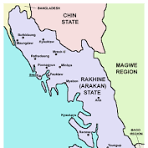
To the west, Arakan faces the Bay of Bengal. In the north-west, the region adjoins Bangladesh. The Naf River forms part of the international boundary in the northern area, with Maungdaw lying along the frontier. To the east, the Arakan Yoma separates much of the coastal region from central Myanmar. This mountain barrier has historically influenced transportation, settlement, trade and communication between Arakan and the interior.
The coastline is characterized by estuaries, tidal waterways, peninsulas, islands and low-lying coastal plains. River valleys and coastal lowlands provide important areas for settlement and agriculture, while extensive waterways have long served as routes of local transportation and communication.
Several important rivers drain through Arakan toward the Bay of Bengal. The Kaladan River is one of the principal river systems of central Arakan and reaches the sea near Sittwe. The Lemro River is another important waterway in central Arakan. Farther north, the Mayu River flows through the area associated with Maungdaw, Buthidaung and Rathedaung, while the Naf River marks part of Arakan's north-western frontier.
Northern Arakan includes the Maungdaw and Buthidaung areas and the Mayu landscape. Maungdaw lies along the Bangladesh frontier and the Naf River, while Buthidaung lies farther inland. Hills and river valleys divide the northern landscape, and waterways have historically provided important connections between settlements.
Central Arakan includes Sittwe and the valleys of the Kaladan and Lemro rivers, as well as the historically important Mrauk-U area. River valleys, agricultural plains, wetlands and surrounding hills characterize much of this part of the region. Sittwe, situated near the coast and the mouth of the Kaladan river system, is one of the principal urban and maritime centres.
Southern Arakan includes extensive coastal areas, islands and peninsulas around places such as Kyaukphyu, Ramree, Munaung, Thandwe and Gwa. The coastline becomes increasingly broken by bays, islands and offshore waterways. Fishing, maritime transport and coastal agriculture have consequently played important roles in the geography and economy of these areas.
Arakan has a tropical monsoon climate. The south-west monsoon brings heavy seasonal rainfall from the Bay of Bengal, particularly to the western slopes of the Arakan mountain range. The mountains act as an important climatic barrier, producing very wet conditions on their western side while helping shield central Myanmar from much of the moisture arriving from the Bay of Bengal.
Heavy monsoon rainfall supports rivers, wetlands, forests and agriculture but also creates significant natural hazards. Flooding, landslides and erosion occur during periods of intense rainfall, while coastal communities are exposed to tropical cyclones and storm surges originating over the Bay of Bengal.
The combination of mountains, rivers, fertile valleys, islands and an extensive coastline has strongly influenced Arakan's historical development. The Arakan Yoma limited easy overland communication with central Myanmar, while rivers and the Bay of Bengal connected the region with neighbouring coastal areas and wider maritime networks. As a result, Arakan's physical geography has played an important role in shaping its settlement patterns, agriculture, transportation, trade and historical connections with the Bay of Bengal region.