Geography
Arakan is a coastal region situated along the eastern shore of the Bay of Bengal in western Myanmar. Its geography is defined by a long coastline, river valleys, islands, coastal plains and the Arakan Yoma, also known as the Rakhine Yoma, which forms a major mountain barrier between the coastal region and the interior of Myanmar.
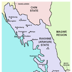
To the west, Arakan faces the Bay of Bengal. In the north-west, the region adjoins Bangladesh. The Naf River forms part of the international boundary in the northern area, with Maungdaw lying along the frontier. To the east, the Arakan Yoma separates much of the coastal region from central Myanmar. This mountain barrier has historically influenced transportation, settlement, trade and communication between Arakan and the interior.
The coastline is characterized by estuaries, tidal waterways, peninsulas, islands and low-lying coastal plains. River valleys and coastal lowlands provide important areas for settlement and agriculture, while extensive waterways have long served as routes of local transportation and communication.
Several important rivers drain through Arakan toward the Bay of Bengal. The Kaladan River is one of the principal river systems of central Arakan and reaches the sea near Sittwe. The Lemro River is another important waterway in central Arakan. Farther north, the Mayu River flows through the area associated with Maungdaw, Buthidaung and Rathedaung, while the Naf River marks part of Arakan's north-western frontier.
Northern Arakan includes the Maungdaw and Buthidaung areas and the Mayu landscape. Maungdaw lies along the Bangladesh frontier and the Naf River, while Buthidaung lies farther inland. Hills and river valleys divide the northern landscape, and waterways have historically provided important connections between settlements.