The Destruction of Rohingya Settlements
Between October and November 2016, extensive sections of Rohingya villages in northern Maungdaw Township were destroyed by fire during Myanmar's military operations. Entire residential neighbourhoods disappeared, together with houses, shops, stored food, household possessions and places of communal importance. The destruction affected settlements that had supported Rohingya families for generations and left survivors facing the loss of both their homes and the material foundations of their lives.
The burning was documented through Rohingya eyewitness accounts and satellite imagery analysed by international human rights organisations. These two forms of evidence were particularly important because the Myanmar authorities restricted independent access to the affected areas and repeatedly disputed allegations that security forces had destroyed civilian property. Satellite observations established the locations and approximate dates of the fires, while witnesses described the movements of armed personnel and the circumstances in which buildings were set alight.
For Rohingya communities, the destruction also raised questions about the participation of local Rakhine nationalist actors and the wider political consequences of removing Rohingya inhabitants from their villages. Some survivors reported looting by ethnic Rakhine civilians accompanying security forces. These accounts deserve examination alongside the documented role of military personnel, rather than treating the violence as the work of uniformed soldiers alone.
Wa Peik: The Beginning of the Village Burnings
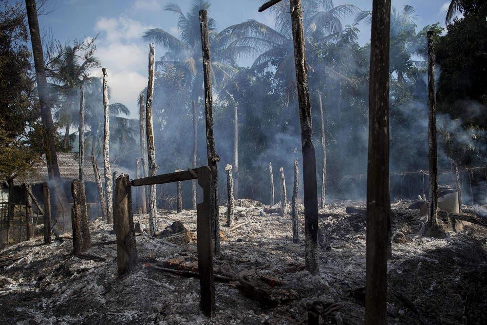
The destruction occurred in several separate episodes over approximately one month. This pattern was significant because it demonstrated that the village had not suffered a single accidental fire during the immediate confusion following the attacks on border police installations. Instead, successive observations showed new damage appearing in areas that had previously remained intact.
A major Border Guard Police installation was situated beside Wa Peik. The proximity of security personnel raised questions about official explanations that attributed the destruction to Rohingya militants. Satellite evidence could establish the location and progression of the fires, but identifying those who ignited particular buildings required eyewitness accounts and other supporting evidence.
The repeated burning left residents facing the disappearance of homes and neighbourhood infrastructure. For families whose houses survived an earlier incident, subsequent fires created renewed danger and uncertainty. The destruction of Wa Peik became an early indication that Rohingya residential settlements themselves were being devastated during the security campaign.
Kyet Yoe Pyin: Burning, Looting and Civilian Participation
Kyet Yoe Pyin, also known locally as Kari Paraung, was among the most extensively damaged settlements during the first week of operations. Human Rights Watch identified approximately 245 destroyed buildings through satellite imagery covering the period from 9 to 14 October 2016. The damage included residential structures and commercial premises, affecting both family homes and the local economy.
Rohingya witnesses interviewed by Human Rights Watch described security personnel entering the village, firing weapons and setting houses alight. Survivors reported the use of flammable materials and attacks on buildings while inhabitants attempted to escape. Their accounts connected the physical destruction visible in satellite imagery with specific actions attributed to armed personnel.
The testimony concerning Kyet Yoe Pyin also provides an important basis for examining the involvement of local Rakhine civilians. A survivor identified under the pseudonym Kasim described ethnic Rakhine villagers accompanying soldiers and participating in the looting of Rohingya houses. His account indicated that the removal of property was not confined to uniformed security personnel.
This evidence is particularly important because it concerns the October 2016 operations themselves. It demonstrates that allegations of cooperation between security forces and local Rakhine participants were not limited to the later 2017 campaign. However, the testimony does not establish that all Rakhine villagers participated or that Rakhine civilians were responsible for most of the fires.
The destruction of the local market added another dimension to the losses. Shops contained merchandise, supplies and accumulated investments belonging to Rohingya traders. Their burning or looting deprived families of income and disrupted the commercial relationships on which the surrounding community depended.
Pyaung Pyit: Destruction Beyond the Main Security Installations
Pyaung Pyit, also identified as Ngar Sar Kyu, was included in Human Rights Watch's earliest satellite assessments. Approximately 85 destroyed buildings were identified through imagery collected during October and early November 2016. The damage demonstrated that village destruction extended beyond the immediate surroundings of the police installations attacked on 9 October.
Together, Wa Peik, Kyet Yoe Pyin and Pyaung Pyit accounted for an initial documented minimum of approximately 430 destroyed structures. These findings were subsequently expanded as additional satellite imagery became available. The early count should therefore be understood as a preliminary measurement rather than the complete extent of destruction.
The importance of Pyaung Pyit lies partly in its contribution to the geographical record. The village formed part of a wider pattern in which multiple Rohingya settlements experienced severe fire damage during the same military campaign. The destruction could not be adequately explained as damage confined to a single confrontation or one isolated neighbourhood.
For displaced inhabitants, the disappearance of houses also threatened their ability to demonstrate continued occupation and maintain access to property. The loss of physical structures could create further difficulties in an environment where Rohingya land rights and documentation were already insecure.
The November Expansion: Dar Gyi Zar and Surrounding Villages
During November 2016, extensive burning spread to additional Rohingya settlements. Satellite observations identified fires in Pwint Hpyu Chaung on 12 November, Dar Gyi Zar on 13 November and Yae Khat Chaung Gwa Son between 13 and 15 November. These events marked a major expansion in the geographical extent of destruction.
Human Rights Watch's November assessment identified approximately 820 additional destroyed buildings across five villages. These included 265 in Dar Gyi Zar, 255 in Yae Khat Chaung Gwa Son, 65 in Pwint Hpyu Chaung, 15 in Myaw Taung and approximately 220 additional structures in Wa Peik.
Dar Gyi Zar was among the most severely affected settlements. Rohingya survivors described armed personnel entering the village and setting buildings alight. One witness, identified as Chomi, reported observing soldiers attacking the settlement on 13 November. On returning, he found extensive damage and the disappearance of household possessions.
Subsequent satellite observations identified further burning in Dar Gyi Zar between 18 and 23 November. The repeated appearance of new damage demonstrated that destruction continued after the initial November attacks. Some families who had fled temporarily discovered that buildings surviving an earlier incident had subsequently been burned.
The geographical progression was significant. The November fires affected settlements several kilometres west of villages damaged during October, indicating that the destruction was expanding into additional Rohingya residential areas.
Yae Khat Chaung Gwa Son: Houses Burned Individually
Yae Khat Chaung Gwa Son experienced widespread destruction during the November operations. Human Rights Watch identified approximately 255 destroyed buildings, while satellite thermal observations recorded active fires over several days.
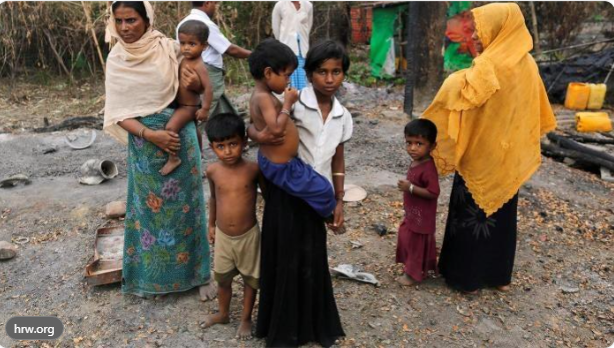
The destruction of individual houses carried consequences beyond the immediate loss of shelter. Families lost clothing, cooking equipment, stored food, savings and personal documents. In agricultural communities, the destruction of household storage could also eliminate seed supplies and tools needed for future cultivation.
The pattern of repeated burning across neighbouring settlements suggested a campaign affecting residential areas rather than a series of unrelated accidental fires. Determining responsibility for each individual building nevertheless requires evidence beyond satellite imagery alone.
Military Firepower and the Destruction of Civilian Areas
Rohingya survivors described military operations involving gunfire, armed ground personnel and, during the wider campaign, helicopter activity. International human rights investigations documented allegations that helicopters fired on civilians in November 2016. These reports are important because they demonstrate the military capabilities deployed in an area inhabited by families with little means of protection.
The relationship between aerial operations and individual village fires requires careful reconstruction. Evidence that helicopters operated or fired in an area does not automatically establish that aircraft ignited every building subsequently destroyed. Ground-level testimony and satellite observations remain essential for identifying how particular settlements were burned.
The combination of military firepower and attacks on civilian property created conditions in which inhabitants were forced to choose between remaining in danger and abandoning their homes. Armed personnel could control access to villages while residents fled, leaving property exposed to destruction or theft.
The use of heavy military force against civilian areas also raises questions about proportionality, distinction and the responsibility of commanders to protect non-combatants. These legal questions must be assessed according to the circumstances of each operation, but the available investigations established substantial evidence of serious violations against Rohingya civilians.
Rakhine Nationalist Participation in the Destruction and Looting
An important aspect of the Rohingya account of the 2016 violence concerns the participation of local Rakhine actors alongside Myanmar security forces. Rohingya survivors have described situations in which soldiers entered settlements while accompanying civilians removed possessions from houses or assisted in intimidating residents.
The testimony concerning Kyet Yoe Pyin provides a documented example. Human Rights Watch recorded allegations that ethnic Rakhine villagers participated in looting during operations involving security personnel. Such accounts challenge any assumption that the destruction and appropriation of Rohingya property were exclusively military activities.
The participation of local civilians could serve several purposes. Individuals might obtain household goods, commercial merchandise or other possessions from abandoned homes. Others might act from hostility toward Rohingya neighbours or support for nationalist campaigns seeking their exclusion. Establishing the motives of particular participants requires evidence concerning their conduct, affiliations and statements.
Rohingya observers have argued that some Rakhine nationalist actors regarded the military operations as an opportunity to remove Rohingya communities from areas they considered exclusively Rakhine territory. This interpretation must be examined in the context of earlier nationalist mobilisation, demands for segregation and opposition to Rohingya citizenship and political recognition.
The available evidence does not establish that most village burnings during October–November 2016 were physically carried out by Rakhine civilians. It does, however, provide grounds to investigate participation in looting and other abuses. The distinction is essential because different perpetrators may have played different roles in the same operation.
Responsibility must be assigned to identifiable participants and organisations, not to the Rakhine population as a whole. Rakhine civilians who did not participate in violence cannot be held responsible for acts committed by soldiers, armed groups or other individuals.
The Question of Exclusive Ownership of Arakan
For many Rohingya, the destruction of villages was inseparable from a longstanding struggle over belonging, citizenship and territorial identity in Arakan. Rohingya communities regarded the land as their ancestral homeland, while some Rakhine nationalist movements rejected Rohingya historical identity and promoted political narratives that excluded them from the region.
The destruction of Rohingya houses, markets and religious institutions had consequences that extended beyond immediate material loss. When families were expelled and buildings disappeared, the physical evidence of their presence could be weakened. If displaced residents were subsequently prevented from returning, the destruction could contribute to permanent demographic and territorial changes.
Rohingya critics have therefore interpreted cooperation between military forces and local nationalist actors as serving overlapping interests. Myanmar's military could expand coercive control over Rohingya communities, while particular nationalist groups could benefit from the removal of a population whose presence challenged exclusive claims to Arakan.
This interpretation is historically important, but the existence of overlapping benefits does not establish that every participant shared a single coordinated plan. A stronger evidentiary record would identify specific nationalist organisations, statements calling for Rohingya removal, instances of property occupation and administrative decisions preventing return.
The Rohingya claim to historical belonging cannot be erased by the destruction of houses or the displacement of families. The history of a community is not extinguished merely because armed actors destroy its settlements or deny its identity.
The Looting of Rohingya Property
The destruction of homes was accompanied by allegations of theft and removal of possessions. Survivors described the disappearance of money, jewellery, clothing, household utensils, livestock and commercial goods. In some cases, property was reportedly taken before buildings were burned; in others, residents discovered their belongings missing when they attempted to return.
Looting was particularly damaging because it deprived survivors of the resources needed to rebuild. A family that lost its house but retained savings and equipment might still possess some means of recovery. A family whose house, possessions and livelihood were all destroyed faced far greater obstacles.
The involvement of accompanying civilians, where documented, raises additional questions about the relationship between military operations and private appropriation of property. Armed forces controlling a settlement could create conditions in which others entered homes or removed goods without resistance from residents.
The available evidence supports investigation of such incidents, but it does not provide a complete inventory of stolen property or identify every perpetrator. Rohipedia should therefore preserve individual testimonies, village names, approximate dates and descriptions of missing possessions wherever these can be reliably documented.
Mosques and the Destruction of Community Life
The United Nations Human Rights Office's February 2017 investigation recorded testimony concerning the burning of mosques in several Rohingya villages, including Kyet Yoe Pyin, Wa Peik, Pwint Hpyu Chaung and Yae Khat Chaung Gwa Son. Survivors also reported the destruction of Qurans, prayer mats and other religious materials.
Mosques were central institutions in Rohingya village life. They served not only as places of worship but also as locations for religious education and community gathering. Their destruction therefore damaged the social and religious infrastructure through which families maintained communal relationships.
Where religious buildings were deliberately targeted, such acts raised questions about discriminatory intent beyond the stated purpose of security operations. The burning of a mosque could not automatically be explained as an attempt to recover weapons or apprehend attackers.
The destruction of markets, religious institutions and residential neighbourhoods together weakened the foundations of community life. Even when some inhabitants remained nearby, the disappearance of shared institutions made the restoration of ordinary village activities increasingly difficult.
Official Denial and the Evidence of Satellite Imagery
Myanmar authorities disputed allegations that security forces were responsible for the fires. Official statements accused Rohingya militants of burning their own homes and presented substantially lower estimates of destruction than those identified by independent investigators.
In November 2016, government and military representatives reported approximately 30 to 60 destroyed buildings in Dar Gyi Zar. Human Rights Watch subsequently identified approximately 265. Official figures concerning Wa Peik were also considerably lower than the approximately 320 structures documented through later satellite analysis.
These discrepancies were significant because they concerned entire neighbourhoods. High-resolution satellite imagery enabled investigators to compare the same locations before and after the fires and identify structures that had disappeared or been severely damaged.
By December 2016, Human Rights Watch had documented at least 1,500 destroyed buildings across Rohingya settlements. Witness interviews also implicated security forces in deliberately setting homes alight. The combined evidence challenged the government's attempts to attribute the destruction primarily to Rohingya militants.
The findings established a record of physical destruction that could be examined independently of official statements. They also demonstrated the importance of preserving satellite imagery, survivor testimony and dated observations for future accountability investigations.
The Long-Term Consequences of Village Destruction
The burning of Rohingya settlements caused immediate displacement, but its consequences extended into questions of land ownership, return and demographic change. Families who lost houses, documents and possessions faced serious difficulties establishing their claims to property and rebuilding their lives.
The destruction of a village could also alter the relationship between its former inhabitants and the surrounding territory. Where residents were unable to return, abandoned land became vulnerable to occupation, administrative reclassification or other changes that might weaken their future claims.
These consequences support the Rohingya concern that village destruction could serve broader objectives of exclusion. However, the historical record must distinguish the destruction documented in 2016 from subsequent land seizures, resettlement schemes and restrictions imposed during later phases of the crisis.
The military's later loss of extensive territory to the Arakan Army introduces a separate historical question concerning the long-term consequences of its relationship with Rakhine nationalist movements. That development belongs to the later chronology of the conflict. It cannot establish what military commanders intended in October 2016 or whether they subsequently regarded earlier policies as a strategic mistake.
The October–November 2016 destruction nevertheless remains a major episode in the historical record of Rohingya persecution. Satellite evidence and survivor accounts documented the burning of residential areas, damage to community institutions, loss of property and the participation of security forces in attacks on civilian settlements. Testimony concerning local Rakhine involvement adds an important dimension that requires continued investigation.
The next chapter examines the human consequences of these operations, including killings, sexual violence, arbitrary arrests and disappearances. It will focus on the experiences of victims and survivors without repeating the village-by-village destruction documented here.